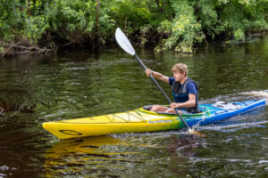
Photo by Joseph Frederick
December 17, 2024
Paddling Adventures in Lincoln County
After a day of being “Schotzed” on our mountain bike trails or hiking one of the many Ice Age Trail segments, your legs might be telling you they need to relax - so it’s time to get some paddling in!
Almost all our paddling options are very family friendly and great for the beginner. What Lincoln County doesn’t offer in the form of whitewater, it more than makes up with scenery and wildlife.
Twenty-eight of Lincoln County’s 500 lakes offer easily accessible boat landings. A list of landings and maps to lakes may be found at https://www.co.lincoln.wi.us/recreation/page/boat-landings.
The Prairie River usually flows between 150-200 cubic feet per second (cfs) in the summer. Many parts of the river are shin deep with occasional four-foot-deep holes in normal conditions. The most popular portion of the river starts where County Road C crosses the Prairie about five miles north of town. While there is no formal access area, put-in is typically done from the bridge eastward. Starting at this point offers about a 7.5-mile stretch of easy flowing river. The first couple miles may have a few branches or small trees blocking your path. About halfway to the Wisconsin River, paddlers cross under County Road K (Business 51) at Prairie Trails Park, where a boat landing is located on the left side of the river between the two bridges. Another two miles takes you to Stange’s Park along Third Street in Merrill. During those two miles, you will never know you are going through a residential district. This is the paddling segment of the Black Squirrel Scurry Triathlon held in late July. A popular take-out is to the right riverbank on either side of the bridge – either Lions Park before or Stange’s Park beyond, with parking lots located near the river. For those of a bit more adventurous ilk, one might continue on to the Wisconsin River over a brief 1-foot drop through the rocks that anyone with whitewater experience can handle. There is a takeout just before the dam on the left.
Experienced kayakers may start higher up the river but be forewarned, there is a significant whitewater section at Prairie Dells that would be considered at least a Class III rapids. To be on the safe side, it’s easier to take this when the river flow is 350 cfs or more, as you’ll have water to work with and will start to get over some rocks.
Other small rivers – Pine, Newwood and the Upper Prairie (north of Gleason to Hay Meadow County Park) - offer wilderness adventure paddlers a rustic take on the trek as flow is small and branches add a level of difficulty. Travel is best when the Prairie USGS station reports over 300 cfs. These are not recommended for novice/beginners. Check your maps to look at distances and put-in/takeout opportunities when the roads cross.
The gem of outdoor water recreation in Lincoln County – the Wisconsin River - has been added to the Great Pinery Heritage Waterway, a scenic water trail that extends 108 miles plus parts of its tributaries. Recent inclusion will stimulate more landings, signage and recreational opportunities, plus access to services that presently don’t exist. To be at the site of the crux of the Ice Age Trail and this historic waterway is a unique opportunity for any outdoor adventurer.
The Wisconsin River offers long, clear stretches to paddle while viewing a variety of wildlife such as deer, eagles, waterfowl, turtles and otters. Occasional rock outcrops and ripples offer a little diversion. The series of dams have portages. Often, below the dams, the river can be easily waded.
Entering Lincoln County just south of Rhinelander, the Wisconsin River winds into Lake Alice, crosses under Hwy. 51 and flows into Lake Mohawksin in Tomahawk, joined by the Spirit Flowage from the west. The landing at SARA Park in Tomahawk offers a locker room with bathroom and shower facilities. These two flowages offer many spots to dock by businesses for food and refreshments and many bays and inlets to explore.
As you leave Tomahawk, the river offers a casual paddle entering the Grandfather Falls Flowage. Perhaps the most interesting area of this paddle comes as you intersect the Ice Age Trail. There you’ll see part of the Wisconsin River flow through penstocks and have the opportunity to camp at Newwood County Park, formerly a Civilian Conservation Corps site. Take the time to walk amongst the rocks below the last dam above Newwood County Park. It’s the most stunning view in the county – breathtaking when the fall colors peak.
From here you have an 11-mile paddle to Council Grounds State Park. The only rapids that you’ll encounter will find you quickly. Posey Rapids, level I, and Bill Cross, Level II, are each a short, small challenge that a beginner can handle as they are brief and shallow. The end of Lake Alexander offers a boat landing and a beach just before the dam on the left. Showers, bathrooms and walk-in campsites are available. From Alexander Dam, the paddle takes you into Merrill from the West Side to the Merrill Hydropower Dam located near Main Street. Below the dam, Riverside Park on the right, just past the put-in, offers frisbee golf. Many people will paddle to what was formerly known as Brokaw, but there is a takeout just at the county line on private property on the right bank of the river. This takeout is not marked so it’s recommended you check out the landing ahead of time. An island marks the general area of the takeout. There is a small, gravel parking lot available and a double track lane just south of the lot to approach the river. The road has limited visibility, so it is requested to use the lot and not park on the side of the road. Travel time down the river is 1 ½ - 2 ½ hours, depending on current and paddling intensity. For more information on the Great Pinery Heritage Waterway, check out https://greatpinery.com/.
Article written by Greg Eichelkraut
Paddle The Great Pinery Heritage Waterway™

April 24, 2024
Located at the convergence of the Prairie and Wisconsin Rivers, Merrill is the perfect location for water enthusiasts, especially those who enjoy a silent glide down the river punctuated by the sounds of nature and their oar slicing the water.
Canoeing and kayaking are the perfect way to spend an afternoon, evening, or even an entire day on the water.
Opportunities for places to put in to one of the hundreds of Lincoln County Lakes or an area river abound, but today let’s take a look at one of our most beautiful and local natural resources—The Great Pinery Heritage Waterway™.
A 50-mile Journey through Lincoln County in a Canoe or Kayak
The Great Pinery Heritage Waterway™ is a 108-mile navigable water trail located in Northcentral Wisconsin, situated on the Wisconsin River and its tributaries, spanning several counties. The trail snakes through Lincoln County for over 50 miles, starting its epic journey at the first trailhead at Hat Rapids Dam in Oneida County and ending its journey at the Marathon County line. Portions of the trail hold scenic wonders as it flows over rapids and rock outcroppings, through primeval pine and hardwood forest, bisecting state wildlife and natural areas, paralleling the Ice Age National Scenic Trail as it tumbles over the second highest waterfall in the state at Grandfather Falls.
The Great Pinery Heritage Waterway winds through scenic forests, urban landscapes and historic sites, inviting paddlers to immerse themselves in the natural beauty of the Great Pinery, learn about the native inhabitants and European settlers who once navigated these waters, and enjoy local attractions, food and happenings.
The great river is never far from our imagination as our paddle dips into its cool waters, each river bend and island sharing a new story, a reminiscent time of a bygone era when rivermen floated the white pine risking life and limb. We paddle past historic dams, CCC camps, and long forgotten sawmills and mill towns that help defined the Great Pinery.
In the 1870’s the river earned a new name as the “Hardest Working River in the World” when men with names like Alexander, Scott, and McCord put the river to work sawing lumber for the cities and homes of the Midwest. It was a different river then, gritty, hardworking, and tough! At times, it would reach out of its banks taking what it wanted from the communities that called its shores home.
By 1907 a group of men had had enough, and they aimed to tame, manage, and regulate the flow of the river, taking away its wildness and turning it once and for all into the river we have today, producing hydroelectric energy so that industry could develop and flourish.
Today, the Wisconsin River has returned to its beginnings, offering the paddler an adventure not soon forgotten! Islands dot its waterway, and the white pine once again blankets its shores.
The Great Pinery Heritage Waterway is a pleasant paddle for recreational and advanced paddlers alike. Several water trail segments offer diverse paddling experiences and you are sure to find one that will appeal to you and your group. Plentiful landings, clear signage, and good overall internet reception make for a stress-free trip.
Article written by Chris Schotz

April 24, 2024
The featured image, date, and author shown above will automatically fill in from the post properties. Add the main content for your post here. You can use the page editor tools to add more content areas and content types.
